
 1
1NASA: ICESat-2 monitors ice loss on Earth
 01. 10. 2018


The US space agency has sent a laser to the orbit that will measure ice conditions on Earth. This mission, called ICESat-2, aims to provide more accurate information on how global warming affects the frozen areas of the Earth. Antarctica, Greenland, and the Arctic glacial areas of the Arctic in the north have lost considerable volumes in recent decades. NASA and its ICESat-2 project will observe and record these changes from 500 to a remote location on the orbit.
As we can assume from the name of the satellite, ICESat-2 is a follow-up to the initial 2009 project. However, this project encountered technical problems - the satellite was limited and could measure and observe only a few months a year. So NASA has reshaped the technology and the satellite should now be more reliable and have more detailed insight.
Professor Helen Fricker of the Scripps Ocean Research Institute explains:
“ICESat-2 will observe the Earth's cryosphere with a spatial resolution we have never seen before. The beam is divided into six rays alone - three pairs - so that we can better map the ice surfaces and the glacier slope itself. This allows us to better interpret the height changes. Every three months, the same glacier surface records are made, giving us an overview of altitude changes in the seasons. ”

Artwork: ICESat-2 shoots 10 000 times per second laser
Why is this NASA mission important?
Antarctica and Greenland lose billions of tons of ice a year. This is mainly the result of the action of warm water, which collides with the land and thus dissolves these coastal glaciers. These masses of ice then help the ocean level rise. In the Arctic, seasonal ice floes were also in decline. Apparently, since 1980, the sea ice of the far north has lost two-thirds of its total mass. And although this has no direct effect on rising ocean levels (they are more like geographical counterparts, with the Arctic surrounded by land and Antarctica the ocean), it causes higher temperatures in the region.
Dr. Tom Neumann, a representative of the ICESat-2 Science Project, says:
"Many of the changes that occur at the poles may seem very vague, and very precise technology is needed to measure correctly. Even a minimal change in height like an inch, on an area like Antarctica, represents a huge amount of water. And up to 140 billion tons. "
How does ICESat-2 work?
This new laser system is one of the largest Earth observation instruments NASA has ever constructed. Weigh a few tons. It uses technology called "photon counting." It shoots approximately 10 000 light pulses every second. Each of these impulses flies down to Earth, reflects, and returns back in a time scale of approximately 3,3 milliseconds. The exact time is equal to the height of the reflecting surface.
Cathy Richardson, a member of the Nasa team who developed this instrument, says:
"We shoot about a billion photons (light particles) every second. Approximately one will come back. We can calculate the time of returning this one photon as accurately as sending it to Earth. And so we can determine the distance to half a centimeter. "
NASA will give us an unprecedented view of the Earth's ice sheets
Laser makes measurements every 70cm.
What does this project provide us with?
Scientists hope ICESat-2 can help create the first comprehensive map of sea ice density in Antarctica. At present, technology to get the information available works only for the Arctic. You need to compare the elevation point of the glacier surface and the sea level. Scientists know the density of sea water and ice, so they can calculate how much ice has to be underwater to determine the total mass of the sea ice.
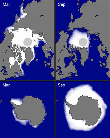
Comparison of sea ice layers in March (Mar) and September (Sep). Up north pole Arctic, down south pole Antarctica
Of course the Antarctic needs to be treated differently. In the far south, seaweed is covered with snow, and it can make the glaciers so heavy that they are fully pushed under water and the calculation is much more complicated. The proposed solution is a combination of the ICESat-2 satellite to help calculate surface height and radar satellite technology that can get deeper into the surface of the snow with its microwave rays. This collaboration could bring more light into the project.
No need to worry, the laser does not have the strength to help melt icebergs from the orbital 500km above ground. But in a dark night one can see the green dot in the sky, when ICES is flying over our area.