
Abaddon
 26. 04. 2024


 2
18. 10. 2023
2
18. 10. 2023

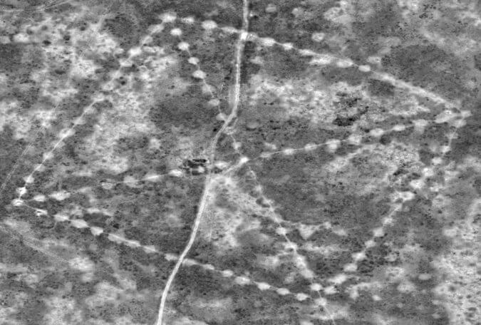
Satellite images of the remote northern steppe reveal huge formations on earth. They are geometric shapes - squares, crosses, lines and circles the size of several football fields, which can only be identified from the air. The estimated age of the oldest of them is 8000 years.
The largest of the formations is located near the Neolithic settlement. It has the shape of a huge square with 101 raised piles. Its opposite corners are connected by a diagonal cross. It covers a larger area than the great Pyramid of Cheops. Another has the shape of a three-armed swastika, the ends of which bend counterclockwise.
Around 260 formations in the Turgay region in northern Kazakhstan - ramparts, embankments and ditches - in five basic shapes, archaeologists described at a conference in Istanbul last year as unique and never explored before.
The so-called steppe geoglyphs were found on Google Earth in 2007 by a Kazakh economist and archeology enthusiast Dimitrij Dej. However, they remain a great mystery unknown to the outside world.
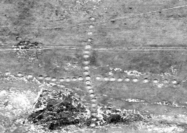
NASA recently released clear satellite images of some shapes from 430 miles away. They have details of size 30 cm. "You can see the lines connecting the dots," Dej said.
"I have never seen anything like it. It's remarkable, "said Compton J. Trucker, a biosphere scientist for NASA in Washington who, along with Katherine Melocik, provided images taken by Digital Globe Dej and the New York Times. He said NASA continues to map the entire area.
NASA has also included photos of the region from space on the cosmonaut's to-do list on the International Space Station.
Ronald E. La Porte, a scientist at the University of Pittsburgh who helped publish the findings, considers NASA's involvement very important to support further research. The footage, archived by NASA, contributed to the summary of Dej's extensive research and the creation of a presentation translated from Russian into English.
"I don't think they were meant for anyone to look at them from above," Dej said 44 in an interview in his hometown of Kostanaj to avoid speculation about aliens and Nazis. (The swastika was an ancient and almost universal element long before Hitler.) The story states that the shapes raised along straight lines were "horizontally observably capturing the movements of the rising sun."
According to several scientists, Kazakhstan, a former Soviet republic bordering China rich in oil, has begun slowly exploring and protecting the site.
"I was worried it was a hoax," said Dr. La Porte, Professor Emeritus of Epidemiology at the University of Pittsburgh, who studied diseases in Kazakhstan and read a report on the findings.
With the help of James Jubille, a former U.S. officer, now the scientific and technical coordinator for health in Kazakhstan, Dr. La Porte Deja and its pictures and documentation quickly convinced them of the authenticity and importance of the findings. They requested images from KazCozm, the state space agency, and urged local authorities to bring the site under UNESCO protection, but so far without success.
In the Cretaceous period 100 million years ago, Turgai was divided by a strait from today's Mediterranean Sea to the Arctic Ocean. In the Stone Age, the rich steppe was the target of tribes looking for hunting grounds. In his research, Dej suggests that the Mahanjar culture, which flourished here from 7000 to 5000 BC, could be related to older formations. But scientists doubt that the nomadic population would remain in one place until they built walls and dug up lake sediments to form huge ramparts with an original height of 6 to 10 feet, now 3 feet and a width of up to 40 feet.
Persis B. Clarkson, an archaeologist at the University of Winnipeg who has seen some of Dej's photographs, claims that these creations and the like in Peru and Chile are changing our current view of nomads.
"The idea that there were enough nomads to create huge structures such as Kazakhstan's geoglyphs has caused archeology to reconsider the nature and timing of large advanced human organizations as forerunners of civilized societies," wrote Dr. Clarkson in the email.
Giedre Motuzaite Matuzeviciute, an archaeologist at Cambridge University who also lectured at the University of Vilnius, visited the area twice last year, claiming that enormous efforts must have been behind the findings. She said through the mail that she had doubts about calling structures geoglyphs - a term used to describe mysterious lines in the Peruvian Nazca. They depict animals and plants because "geoglyphs are an art rather than a functional object."
Dr. Motuzaite Matuzeviciute and two other archaeologists from the University of Kostanaj - Andrei Logvin and Irina Shevnina discussed the figures at a meeting of European archaeologists in Istanbul last year. As no genetic material was available because neither of the two embankments examined served as a burial ground, Dr. used Motuzaite Matuzeviciute optically stimulated luminescence. It is a method of determining age by doses of ionizing radiation. The time of formation of the embankments was around 800 BC Dej, who cited a separate scientific report, refers to the culture of Mahanjar, in which other formations were formed, and suggests the age of the oldest of them at 8000 years.
The finding was a coincidence. In March 2007, Dej watched the "Pyramids, Mummies and Tombs" program on the Discovery Channel. "There are pyramids all over the world," he thought. "They should be in Kazakhstan, too." He soon searched for images of the Kostanaj region on Google Earth. There were no pyramids. But about 200 miles south he noticed something unusual - a huge square with a side of more than 900 feet created by dots crossed by a dotted X.


At first he thought it might be the remnants of Khrushchev's Soviet attempts to cultivate the land. The next day, however, he noticed a huge formation - a three-armed swastika with wavy lines at the ends and a diameter of about 300 feet. By the end of the year, Dej had found eight more squares, circles, and crosses. In 2012, there were 19. Today, its list includes 260 formations, of which some special embankments with two protruding lines, the so-called "mergers".
In August 2007, the team led to the largest formation, now called the Uschogajsky Square after a nearby village. "It was very, very difficult to find anything on earth," he recalls. "Units cannot be found."
When they started digging into one of the ramparts, they found nothing. "It wasn't a tomb with different things," he said. But nearby they found evidence of a Neolithic settlement 6-10 thousand years old, including the tips of spears.
According to Deja, they are planning to build a base for operations. "We can not kick all the embankments. It would not be productive, "he said. "We need modern western-style technologies."
Dr. Laporte said he, Dej and other colleagues planned to use remote-controlled planes used by the Peruvian Ministry of Culture to map and protect monuments.
"But time is against us," says Dej. One of the units called the Koga Cross was destroyed this year during the construction of the road. "And that was after we notified the authorities," he added.